|
|
|
In 1955 Wake Forest College received a tract of land from Reynolda,Inc.
The larger portion of this land was developed into lots which were sold
to faculty and administration. This devel-, opment is designated as
Tax Block 3549. A plat of this property is to.the right. A description
follows:
PROVENANCE: Conveyed by deed January 7,1955 by Reynolda, Inc. to The
Trustees
RESTRICTIONS: None: This tract constitutes the first property designated
for faculty and staff lots. Except for a designated vista, the major
part of the property was divided into 47 lots which were solq to faculty
and staff members and their successors and assigns, in deeds with a
series of restrictions typical of subdivisions of this type, with the
addition of an important provision giving the College first refusal
each time a lot comes up for sale or transfer.
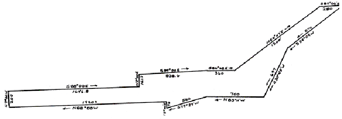
METES AND BOUNDS: The beginning point of this deed starts
at the third call; the first starting at the Southwest intersection
of North Cherry Street and Bethabara Road; running along the South line
of Bethabara Road West 400 feet to a point; thence South 375 feet to
a point, and here starts the beginning of this description:
This point is 150 feet west of the Wake Forest College property and
is in the North line of what is known as Old Town Club property, which
title is owned by Reynolda, Inc. running the following courses and distances:
South 54 degrees 04 minutes West 697 feet to a point, both calls being
along Old Town Club property; continuing along Old Town Club property
83 degrees 11 minutes West 700 feet to a point; South 79 degrees 27
minutes West 540 feet to a point; thence North 2 degrees 00 minutes
East 70 feet to a point in the North and East. line of Reynolda, Inc.1920
feet to a point; thence North 2 degrees 00 minutes East 200 feet to
a point in the South line of Wake Forest College property; thence along
Wake Forest College property the following courses and distances: South
88 degrees 00 minutes East 1646.8 feet to a point; North 2 degrees 00
minutes East 161.7 feet to a point; South 89 degrees 00 minutes East
838.6 feet to a point; South 86 degrees 08 minutes East 360 feet to
a point; North 56 degrees 07 minutes East 1300 feet to a point in the
South line of a Roadway; thence South 89 degrees 06 minutes East 280
feet to the place of the beginning, containing 27.75 acres, as surveyed
by J.G.Ellerbe,C.E. on October 25, 1954 shown on a plat of property
of Reynolda, Inc.
|
|
|
|
PROVENANCE: By Gift Deed December 12, 1962, by the Mary Reynolds Babcock
Foundation, Inc. to the Trustees of Wake Forest College.
RESTRICTIONS This lot is to be used for educational purposes and such
uses incident thereto as may be approved by the trustees of Wake Forest
College including residential sub-division particularly suited to the
housing and other needs of its faculty and other employees, and for
these purposes this tract may be sold or otherwise disposed of by the
party of the second part (The Trustees of Wake Forest College) with
only such restrictions as the party of the second part may impose thereon.
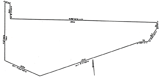
METES AND BOUNDS: Beginning at a point in the Southern right of way
line of Faculty Drive, said point being the Northeastern corner of the
9.52 acres tract no.1; thence with the Southern line of said Faculty
Drive,approximately, South 74 degrees 30 minutes East 61 feet more or
less, to an iron stake, the Northwestern corner of Lot 1 of Wake Forest
Development; thence with the western line of said Lot 1, South 2 degrees
00 minutes West 200 feet to an iron stake, theSouthwestern corner of
said Lot 1; thence with theSouthern line of Lots 1 through 15 of said
Wake Forest College Development, South 88 degrees 00 minutes East 1920
feet, more or less, to an iron stake in the right of a 60 foot street
leading Southwardly from Faculty Drive; thence South 2 degrees 00 minutes
West 70 feet to an iron stake, a Northwestern corner of the Old Town
Club Golf Course tract; thence with said tract the two following courses
and distances, South 34 degrees 35 minutes West 217 feet to a point,
and North 89 degrees 19 minutes West 95 feet to a pont; thence on a
new line, South 71 degrees 55 minutes West 1410 : feet, more or less,
to a pont in the Northern line of the Wake Forest College 124.92 acres
tract; thence with said Northern line, North 66 degrees 45 minutes West
490 feet, more or less, to the Southeastern corner of the 9.52 acres
tract 1; thence with the Eastern line of said tract 1 North 2 degrees
00 minutes, East 750 feet, more or less, to the place of beginning,
containing 22.80 acres, more or less.
|
|
|
|
PROVENANCE: Conveyed by Contract of Sale July 18,1984 and deed delivered
August 1,1984 by Clarence H. Patrick to Wake Forest University.
RESTRICTIONS: This property is restricted to the development of a
retirement community. Certain rights are retained by the grantor in
the event that he resides in this community (see letter of intent);
these do not affect the restrictions of use.
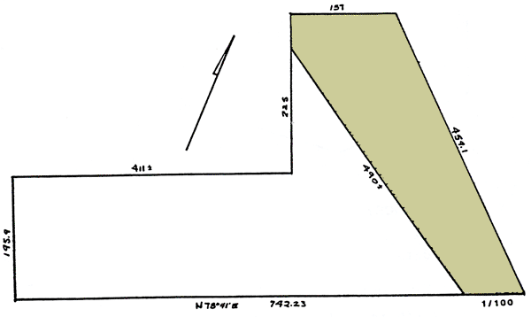
METES AND BOUNDS Beginning at a stake in the Southeast corner of Lot
No.4 as shown on the map of "Chap Bodenheimer" as surveyed by J.A. Walker
Oct.9, 1927, and recordedin Plat Book 135, page 61 (Now Plat Book 4,
page198) in the office of the Register of Deeds of Forsyth County, North
Carolina: running thence North 78 degrees 41 minutes East 742.23 feet
to a stake in the edge of Oldtown Road; thence 30 degrees 52 minutes
West along the Western edge of Oldtown Road 459.1 feet to a stakeat
the intersection of oldtown Road and Maple Springs Road (now Polo Road);
thence Westward along the South edge of Polo Road 157 feet to a point
in the center of the Northern line of Lot No.9, as shown on said plat
of Chap Bodenheimer property; running thence Southwardly in the center
of said lot No.9, measuring East and West; thence Westward parallel
with the Northern line of Lots 9,8,7,6 and 5, 411 feet, more or less,to
a point in the West line of Lot No.5, 195.9 feet distant from the Southeast
corner of lot no.4 as shown on said plat; thence Southwardly 195.9 feet
along the West line of Lot No.4 to the place of the beginning.
SAVE AND EXCEPT from the above boundaries, however, that portion of
same conveyed by Mildred S. Hunter and husband, A.S. Hunter c to the
State Highway Commission of North Carolina. (This portion is shaded
in the plat on the graphic below).
|